The alarm shattered the silence of the morning, and I blinked into life. I rubbed my eyes. I knew it was 3.45 am when I had set the alarm without checking my phone. I sprang out of bed in excited anticipation of the day that was to come.
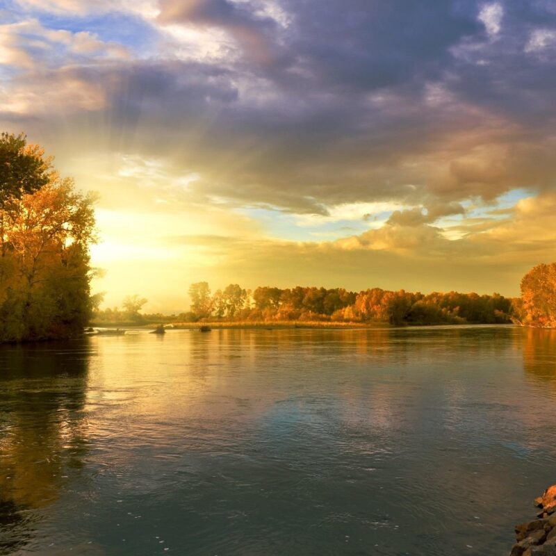
I was parked in a layby, and as I sleepily peered out of the van windows, I could see the shortest night was fading into the longest day. Summer Solstice 2023, and I was near Stonehenge.
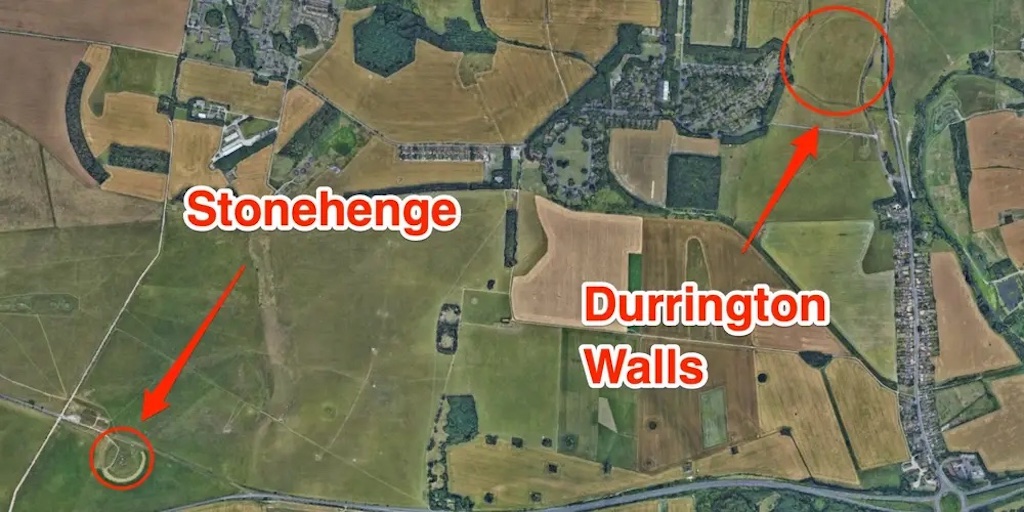
I plan to follow the circular route from Durrington Walls through this ancient and mysterious landscape to Stonehenge and then return to my starting point.
The route is available from the National Trust, which manages the Stonehenge Landscape, meaning the land surrounding the monument is completely free and open to the public. However, Stonehenge itself is managed by English Heritage and admission charges.
After a wash and some breakfast with two cups of coffee, I was sitting on the van floor, putting my walking boots on and listening to the birdsong all around me.
It was still and silent as I set off for my walk. There was a mist that was just beginning to lift. The mist appeared as light and whispy haze dancing just above the ground and seemed to disappear as I walked through it before reappearing behind me.
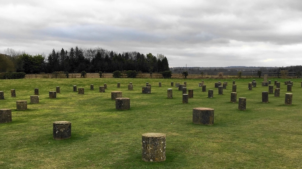
The starting point for me was Durrington Walls, known as a ‘super henge’ enclosure back in the day. A ‘henge’ is a neolithic earthwork with circular or ovular earth banks and an inner ditch. Not all henges contained a stone circle or structure, though.
Durrington Walls
Durrington Walls is known as a henge enclosure because the archaeologists have found evidence of occupation, and it was huge, in fact, the second largest henge in Britain, with only Hindwell in Wales being larger.
In 2023, what you are looking at as an untrained eye – I am not an archaeologist, is a large raised earth bank that runs through or across field boundaries. The grass was dewy from the overnight mist, and my boots were getting wet as I walked up the earth bank and took some pictures.
From here, my route would take me towards Woodhenge. As I walked along, the sound of Blackbirds, Robins and Warblers filled the morning air. My headtorch was still on in its lowest setting, just enough to pick out any obstacles in my way and for me to glance at the OS map when needed. The walking here is level and easygoing.
Woodhenge
Woodhenge is a Neolithic timber monument that dates from around 2500 BCE, which means it is as older than the Stonehenge monument itself.
The feeling of our ancestors is always with you on this walk. It feels like you are just one of many people who have followed this route for thousands of years. Not once did I feel alone throughout the entire walk. As I walked through the early morning light, I couldn’t see another person, but I knew I was not alone.
Woodhenge must have been a great site back in the day. The structure would have stood tall above this gently undulating landscape. Much of my research for this walk was done on the English Heritage website, which tells us that ‘Woodhenge was formed of six concentric ovals of standing posts, surrounded by a bank and ditch, which were built to align with the summer solstice sunrise.”
Today, the magnificent wooden structure has long gone, but they have put concrete posts in the ground that allow you to understand how our ancestors constructed it.
I stood and tried to take in what I could see before me. You can see how the site and monument were formed, but they aligned it for the summer sunrise over 4500 years ago. I wish I could have travelled back to see Woodhenge back then, but for now, I have conjured up a magnificent wooden structure in my imagination, and that’s how I will see it. Please imagine the magnificence and scale of the design for yourselves.
Returning to 2023, I read my research notes and was shocked that we only discovered Woodhenge less than 100 years ago. It was found by aerial photography in 1925.
I started to walk again, this time heading away from the emerging light of the sun and heading west. I passed through a field gate and headed across the field to search for the Cuckoo Stone.
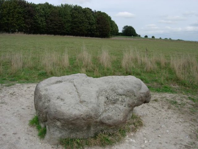
Cuckoo Stone
The Cuckoo Stone is a local Sarsen stone. Sarsen came from the ancient Wiltshire dialect and meant anyone not a Christian. This could refer to Druids or Pagans as an example.
Technically, the stone is silicified sandstone found throughout Southern England but locally from Marlborough to Salisbury. It is a dense and hard rock formed from sand and silica.
The Cuckoo Stone itself is understated. I agree with the line of thought that suggests it would have stood upright originally, although no one can be certain. Look at the picture I took; it has a shape towards the right that would have been the top.
What now appears to be a random lump of stone sitting in a field is around 5000 years old and was once thought to be a magnificent waymarker or signpost.
It is perfectly situated on the axis between Woodhenge, and the Curces, which we will be visiting later on in the walk and the River Avon that runs less than 100 meters to the East of Woodhenge. Perhaps it was to guide people who arrived in boats via the River?
As I left the Cuckoo Stone, I pondered the many mysteries along this route. I headed South through a field towards a gate I couldn’t see at the moment.
As the gate came into sight in the still misty early morning light, I knew I was to take a turn right turn. This path was straight and flat, and stopping to check my notes and take a sip of water, I realised I was now on the route of the former Larkhill Military Light Railway from Amesbury to Larkhill.
The railway was built in 1914 and ran throughout WW1 until decommissioned in 1929. To my right was an area of woodland that was attracting my interest.
The woodland had some maturity to it and was broadleaved, mainly oak and beech and the birdsong coming from it was very different to the birdsong I had been enjoying until now.
The Song Thrush had replaced its close cousin, the blackbird, and I could make out the song of finches and warblers, but one bird’s harmony and range were far superior. I stood quietly and listened to the magnificent melody of the nightingale. Beautiful.
The woodland was fenced and had signs saying it was used by the military, and whilst there were no flags flying today, I decided not to investigate it further.
Just a short way further along the old railway line, I reached another path running North to South across my path. I headed south towards the King’s barrows.
Kings Barrows
The King’s Barrow Ridge was constructed in the bronze age and consists of barrows and burial mounds that lie all along it. The Old King Barrows and the New King Barrows date from around 2,200 –1,600 BCE.
These barrows are from roughly the same period as the third phase of the building at Stonehenge. The Old King Barrows consist of seven bowl barrows that all lie north of the Avenue, whilst the New Kings Barrows consist of five bowl barrows and two bell barrows that stand south of the Avenue.
The Avenue is lined with Beech trees on both sides. Many of the trees are knarled and twisted and definitely of a good age, possibly 300-400 years as a guess, but certainly nowhere near the age of the burial mounds.
As I walked along the Avenue, looking at the lines of burial mounds, I couldn’t help but wonder about the life story of those buried within these beautiful grass-covered banks. I would like to think that they had a line of magnificent trees lining the barrow in the thousands of years between the burials and these old but relatively modern beech trees.
As I walk along the Avenue in the early morning light, there is a wonderful and mystic feeling. The sun is still below the horizon, although its golden yellow and orange light is beginning to illuminate the ground, and I turn off my headtorch.
As I left the Avenue, I began to head towards the Cursus Barrows that run in an east-west layout. This is a collection of barrows of differing shapes, which are thought to date from around 3,500 BCE, predating the very earliest phase of the Stonehenge monument.
My research suggests 16 to 18 barrows within the cursus, but some are no longer visible. With the Cursus barrows being so close to Stonehenge
They have received a lot of archaeological attention since around the 18th century.
Various centuries-long excavations have revealed many burials, such as inhumations and cremated remains. The items buried with their dead owners are vast and varied and have included bronze daggers and awls, amber beads, various beakers and urns, deer antlers and flint tools.
Interestingly, one burial mound excavation revealed chippings of Welsh blue stone that Stonehenge is made from. However, these mounds predate Stonehenge – so there is another mystery, and no, I don’t have an answer for you.
Walking along the Cursus towards the Fargo Plantation, I get my first glimpse of Stonehenge in the distance. As previously explained, I am not an archaeologist, so forgive my layman’s descriptions of what I can see.
Just coming into view is a large bell barrow about 3.5 metres tall. It must be about 25 -30 metres in diameter. It has a ditch enclosing it.
Up next is what appears to be a double mound; perhaps a couple was buried independently, or maybe brothers, I don’t know, but they are impressive, standing slightly shorter at maybe 3 metres tall, and both mounds are enclosed by a more oval shape ditch.
The barrows keep on coming; I can see another group of four barrows that I think are individual and not a group, and just beyond them, another bell barrow.
I understand that each barrow is numbered as Amesbury or Winterbourne Stoke, and you can research each barrow individually. So there is a bit of homework for you.
I’m heading towards the Fargo Plantation, which contains a Hengiform enclosure. Today all you can see is a hollow in the ground. I’m not sure how it has been partially filled in, but it is undulating and irregular at its base.
My notes tell me that the site was excavated in 1938, and at the centre of the area was a grave containing a skeleton with a beaker and a food vessel so someone was well prepared for the afterlife.
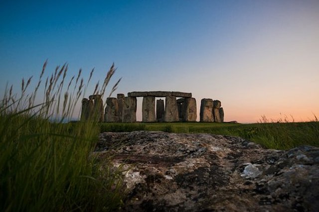
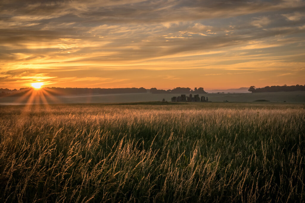
An ancient approach view of Stonehenge
I’m getting close to Stonehenge now, and the sun is beginning to peek above the horizon. The magnificent blue stones are now clearly in view, and my legs seem to be pushing me forward with excitement and anticipation.
The path turned quite sharply in front of me, and the full majesty of Stonehenge came into view, and I was in a direct line to the rising sun. The information board later told me that the path axis aligns with the sunrise at the Summer solstice and sunset at the winter solstice.
I am aware that I am just one of many generations who have walked this path on this very day for thousands of years. I can’t help but feel the stirring emotions deep within me.
I’ve noticed the original banks and ditches running along the path and a large barrow to the side of me, and I can see a huge group of people gathered around the stones. It feels like I have completed my pilgrimage, and a happy elation spreads throughout my body.
As I arrived at the fence separating the Stonehenge Landscape from the English Heritage triangle of land that surrounds the famous stones, I stood and watched the Druid celebrations that were already underway.
The path I was on gave an excellent view of the sunrise, and you could hear the voices of those celebrating and their chants and incantations. I decided not to pay the admission fee and instead to sit here and enjoy the view. The security guys kept a low profile around the monument’s edge, smiled, and said good morning to me.
I set up my tripod and got the camera ready. I was almost directly in line with the sun as it spread its light through the ancient stones.
A couple of hours passed by in a blink of an eye. I sat on the floor and poured a coffee from my flask. I had an overwhelming feeling of sharing an experience with the present and the many people past.
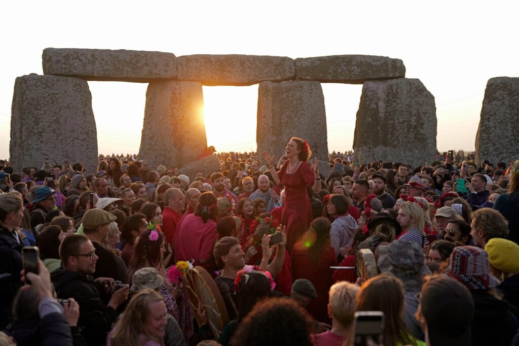
Summer Solstice 2023 Celebrations
I sat and watched in awe and contemplation.
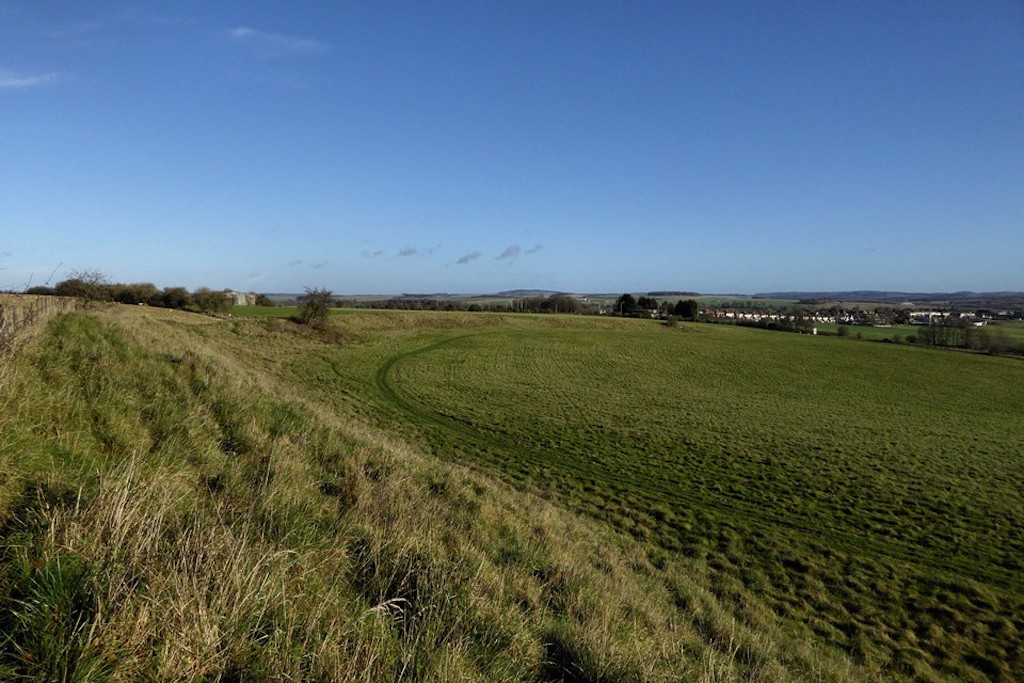
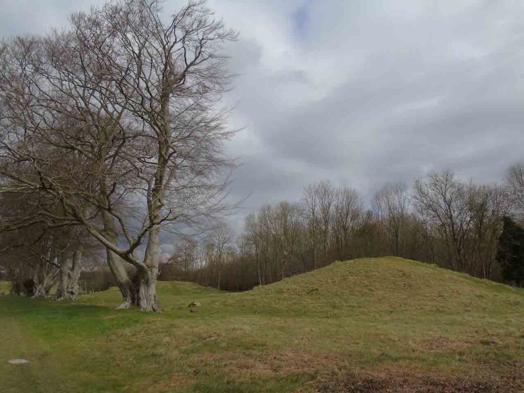
But that was the end of this magical day. With the warm sun sitting high in the late morning sky, I decided to say my goodbye to Stonehenge for now and start the walk back, but there was one more barro I wanted to see.
It is called the Monarch of the Plain, and I felt it was calling me. I didn’t know why.
I set off following my OS map grid reference. I knew the barrow was at the western end of the Fargo plantation and began to read my notes as I walked along the Avenue.
The Monarch of the Plain is one of the larger Bell barrows in the Circus. It sits on the edge of the woodland plantation in an open field. It is visible, unlike some of the barrows and is an imposing 58 metres in diameter, standing around 2.5 metres tall.
A small oak (undoubtedly my favourite) tree stands in front of it as you approach, covered in grasses and with a healthy smattering of wildflowers. The Ox-eye daisies (one of my favourites )are most prominent as they dance in the gentle midday breeze.
Although excavated in 1938, more perceived value was needed. The charred wood perhaps used as a funeral pyre, or maybe it is the spirit of the woodland that is so close to my heart.
Whatever drew me towards the Monarch, I was very pleased to have made your acquaintance, and I will return again.
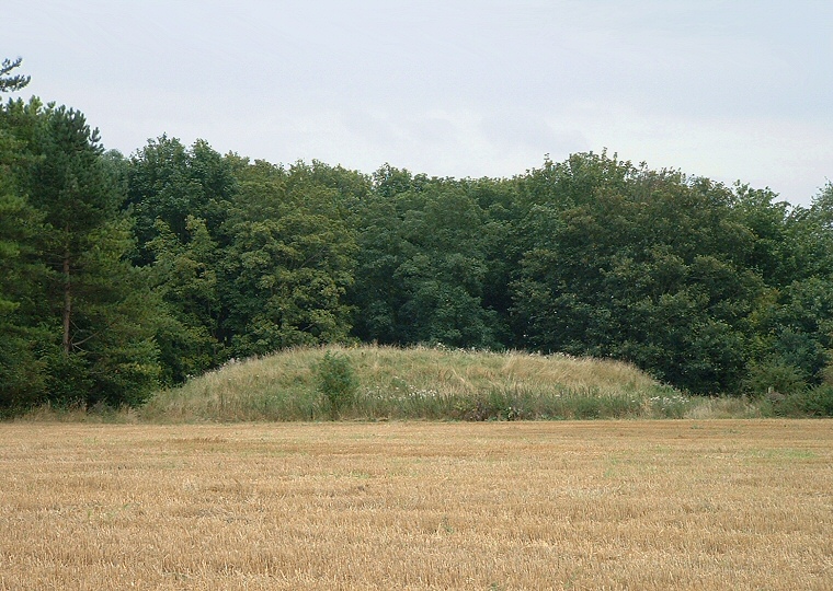
The Monarch of the Plain Bell Barrow
Here is the picture I took of the Monarch of the Plain, and it is a very fitting way to end my adventure through the bronze age on summer solstice day 2023.
Further Reading
What is the Solstice Wikipedia
Stone Henge and the Solstice British Museum
If you enjoyed this blog, please check out more of our wildlife blogs here,
or you may prefer to listen to the Wildlife Matters Podcast here.
If you want to support our work, You can donate here